Datoteca:AmchitkaAlaskaLoc.png

Seiteninhalte werden in anderen Sprachen nicht unterstützt.
Ord Wikipedia

AmchitkaAlaskaLoc.png(300 × 219 pixels, grondezza da datoteca: 14 KB, tip da MIME: image/png)

Resumaziun

Descripziun

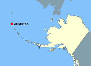
This map is a derivative work of a map layer from nationalatlas.gov, which states: "We have begun by collaboratively building "frameworks," the essential map layers that provide a foundation for all other maps. These basic layers, including small-scale harmonized information on North American roads, water, boundaries and the like, are being offered here for the first time. Like all other raw data and documentation offered here on nationalatlas.gov, these frameworks can be downloaded at no cost and used freely without copyright concerns or license restrictions."[1]

I donate the modifications and the resulting work to the public domain.
Funtauna see above
Autur National Atlas - DW: Jakew

Licenza

Public domain
Diese Karte stammt aus einer Ausgabe des National Atlas of the United States. Wie fast alle Arbeiten der Regierung der Vereinigten Staaten sind Arbeiten des National Atlas in den USA gemeinfrei.
Online-Zugang: NationalAtlas.gov | Gedruckte Ausgabe von 1970: Library of Congress, Perry-Castañeda Library

čeština | Deutsch | English | français | Bahasa Indonesia | italiano | македонски | മലയാളം | sicilianu | 中文 | 中文(简体)‎ | 中文(繁體)‎ | +/−

Ursprüngliches Datei-Logbuch

Die ursprüngliche Dateibeschreibungsseite war hier. Alle folgenden Benutzernamen beziehen sich auf en.wikipedia.
  • 2006-10-08 16:15 Jakew 300×219×8 (14678 bytes) This map is a derivative work of a map layer from nationalatlas.gov, which states: "We have begun by collaboratively building "frameworks," the essential map layers that provide a foundation for all other maps. These basic layers, including small-scale ha

Kurzbeschreibungen

Ergänze eine einzeilige Erklärung, was diese Datei darstellt.

In dieser Datei abgebildete Objekte

Motiv tudestg

MIME-Typ tudestg

image/png

Prüfsumme tudestg

29373e1014db60b020fe042aeb20de37cd506fdd

Bestimmungsmethode tudestg: SHA-1 tudestg

Dateigröße tudestg

14.678 Byte

Höhe tudestg

219 Pixel

Breite tudestg

300 Pixel

Istorgia da las versiuns

Clicca sin ina data/temps per vesair la versiun da lura.

data/tempMaletg da previstadimensiunsUtilisadercommentari
actual23:20, 2. avu 2007Maletg da prevista per la versiun dals 2. avust 2007 las 23:20 uras300 × 219 (14 KB)Adam~commonswiki{{Information |Description=This map is a derivative work of a map layer from nationalatlas.gov, which states: "We have begun by collaboratively building "frameworks," the essential map layers that provide a foundation for all other maps. These basic layer

La suandanta pagina è colliada cun questa datoteca:

Diever da datoteca global

Die nachfolgenden anderen Wikis verwenden diese Datei: