Datoteca:Breakup of Yugoslavia.gif
Seiteninhalte werden in anderen Sprachen nicht unterstützt.
Ord Wikipedia

Datoteca originala(1.545 × 1.242 pixels, grondezza da datoteca: 187 KB, tip da MIME: image/gif, marscha infinit, 14 maletgs, 44 s)

This image could be re-created using vector graphics as an SVG file. This has several advantages; see Commons:Media for cleanup for more information. If an SVG form of this image is available, please upload it and afterwards replace this template with {{vector version available|new image name}}. It is recommended to name the SVG file "Breakup of Yugoslavia.svg" - then the template Vector version available (or Vva) does not need the new image name parameter.

Resumaziun

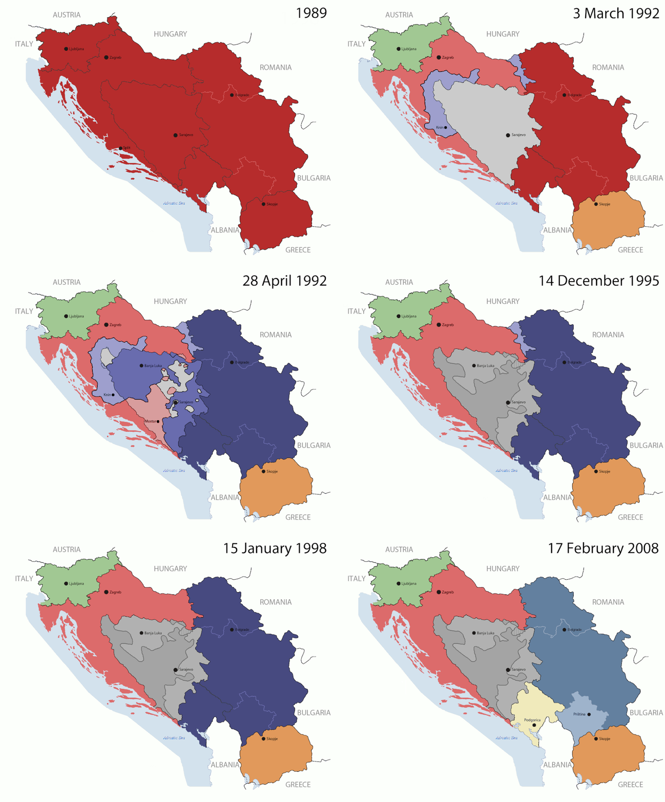
Key:

Yugoslavia (1943–1992) SFR Yugoslavia
Croatia (1991–present) Croatia
Herzeg-Bosnia (1992–1994)
UNTAES (1996–1998)
Federal Republic of Yugoslavia / Serbia and Montenegro (1992–2006) Serbia and Montenegro
Republika Srpska (1992–present) Republika Srpska
Serbian Krajina (1991–1995/96)
Republic of Bosnia and Herzegovina (1992–1995)
Bosnia and Herzegovina (1998–present) Bosnia and Herzegovina
Western Bosnia (1993–1995)
Serbia (2006–present) Serbia
Kosovo (under UNMIK control 1999–present; declaration of independence 2008) Kosovo
Montenegro (2006–present) Montenegro
Macedonia (1991–present) Macedonia
Slovenia (1991–present) Slovenia


Descripziun

This is an animated GIF that shows the stages of the breakup of the SFR Yugoslavia in the 90's and 2000's. The map based off Morwen's map of the divisions of the SFRY, Which is licensed by the GFDL. The source for the dates of independence is the CIA World Factbook. These maps do not now show the Inter-Entity Boundary Line (IEBL) and/or the entities that are separated by it. The IEBL has been drawn based on this CIA map; the Brčko District has been drawn based on Image:BH municipality location.gif, by user:Ante Perkovic. I might add them in the future.

Since the original map was GFDL, this image is as well.

A map depicting Kosovo's final status is ready once it takes effect.


Changelog for versions 2/3:

Here are some changes in this new build of the map:

  • The Kosovo boundary has been given a shade of red instead of the previous UN blue since they are a province of Serbia under UNIMIK control.
  • Montenegro's color has been changed to a golden shade close to what's on the flag.
  • The IEBL and the Brčko District has been redrawn because I deleted the original map; the color for the Republika Srpska is lighter.
  • The dates are at the top left hand corner of the map instead of the bottom.
  • I have taken a new approach as to the boundaries. Each part of Yugoslavia now shows the boundary on the maps starting the year they broke away. I feel this change helps readers understand the breakup better.
  • The SFRY and the FRY are in different shades since the FRY was never accepted as the successor to the former by the UN.
  • The colors for the entities of BiH have been removed as to not confuse people into thinking that they are independent states. What remains is the IEBL with both entities in green.
  • The Kosovo boundary is finally in hash marks!
  • The Brčko District has been removed. The sale is too small to show accurately.

Changelog for version 4:

  • The map is larger!
  • The image has been rebuilt to include the eastern part of FYR Macedonia.
  • The image has been updated to take in Kosovo's new status.
  • The IEBL is now a darker line.
  • Montenegro, Kosovo, and FRY/SCG/Serbia have new colors!

Changelog for version 5:

  • Rebuilt
  • Larger map: size of base image
  • Accurate Inter-Entity Boundary Line
Data 24 July 2006 (orginal upload date)
Funtauna Made by Hoshie; see above for more details on sources.
Autur Hoshie
Andere Versionen

Licenza

GNU head Es ist erlaubt, die Datei unter den Bedingungen der GNU-Lizenz für freie Dokumentation, Version 1.2 oder einer späteren Version, veröffentlicht von der Free Software Foundation, zu kopieren, zu verbreiten und/oder zu modifizieren; es gibt keine unveränderlichen Abschnitte, keinen vorderen und keinen hinteren Umschlagtext.

Der vollständige Text der Lizenz ist im Kapitel GNU-Lizenz für freie Dokumentation verfügbar.

w:de:Creative Commons
attribuziun Weitergabe unter gleichen Bedingungen
Diese Datei ist unter der Creative-Commons-Lizenz „Namensnennung – Weitergabe unter gleichen Bedingungen 3.0 nicht portiert“ lizenziert.
Dieses Werk darf von dir
  • verbreitet werden – vervielfältigt, verbreitet und öffentlich zugänglich gemacht werden
  • neu zusammengestellt werden – abgewandelt und bearbeitet werden
Zu den folgenden Bedingungen:
  • attribuziun – Du musst angemessene Urheber- und Rechteangaben machen, einen Link zur Lizenz beifügen und angeben, ob Änderungen vorgenommen wurden. Diese Angaben dürfen in jeder angemessenen Art und Weise gemacht werden, allerdings nicht so, dass der Eindruck entsteht, der Lizenzgeber unterstütze gerade dich oder deine Nutzung besonders.
  • Weitergabe unter gleichen Bedingungen – Wenn du das Material wiedermischst, transformierst oder darauf aufbaust, musst du deine Beiträge unter der gleichen oder einer kompatiblen Lizenz wie das Original verbreiten.
Diese Lizenzmarkierung wurde auf Grund der GFDL-Lizenzaktualisierung hinzugefügt.

Kurzbeschreibungen

Ergänze eine einzeilige Erklärung, was diese Datei darstellt.

In dieser Datei abgebildete Objekte

Motiv tudestg

Urheber tudestg

Einige Werte ohne einen Wikidata-Eintrag

MIME-Typ tudestg

image/gif

Prüfsumme tudestg

05ca2aefea8406b809968643552d5095c847a42f

Bestimmungsmethode tudestg: SHA-1 tudestg

Dateigröße tudestg

191.625 Byte

Dauer tudestg

44 s

Höhe tudestg

1.242 Pixel

Breite tudestg

1.545 Pixel

Istorgia da las versiuns

Clicca sin ina data/temps per vesair la versiun da lura.

(la pli nova | la pli veglia) Mussar (ils 10 pli novs | ) (10 | 20 | 50 | 100 | 250 | 500).
data/tempMaletg da previstadimensiunsUtilisadercommentari
actual09:40, 17. fan 2016Maletg da prevista per la versiun dals 17. fanadur 2016 las 09:40 uras1.545 × 1.242 (187 KB)מפתח-רשימהReverted to version as of 17:22, 21 August 2015 (UTC)
19:22, 21. avu 2015Maletg da prevista per la versiun dals 21. avust 2015 las 19:22 uras1.463 × 1.158 (1,81 MB)BraganzaReverted to version as of 03:57, 19 January 2010
19:22, 21. avu 2015Maletg da prevista per la versiun dals 21. avust 2015 las 19:22 uras1.545 × 1.242 (187 KB)BraganzaReverted to version as of 01:02, 19 December 2011
19:15, 21. avu 2015Maletg da prevista per la versiun dals 21. avust 2015 las 19:15 uras120 × 95 (3 KB)Braganza03:57, 19. Jan. 2010
03:02, 19. dec 2011Maletg da prevista per la versiun dals 19. december 2011 las 03:02 uras1.545 × 1.242 (187 KB)DIREKTORAdded details
20:09, 27. fan 2011Maletg da prevista per la versiun dals 27. fanadur 2011 las 20:09 uras1.545 × 1.242 (170 KB)DIREKTORSmall fixes
19:28, 27. fan 2011Maletg da prevista per la versiun dals 27. fanadur 2011 las 19:28 uras1.545 × 1.242 (171 KB)DIREKTORAdded UNMIK
18:38, 27. fan 2011Maletg da prevista per la versiun dals 27. fanadur 2011 las 18:38 uras1.545 × 1.242 (165 KB)DIREKTORDates for the last two frames.
14:10, 27. fan 2011Maletg da prevista per la versiun dals 27. fanadur 2011 las 14:10 uras1.545 × 1.242 (149 KB)DIREKTORLighter shade for country names
18:59, 26. fan 2011Maletg da prevista per la versiun dals 26. fanadur 2011 las 18:59 uras1.545 × 1.242 (170 KB)DIREKTORHigher res plus details
(la pli nova | la pli veglia) Mussar (ils 10 pli novs | ) (10 | 20 | 50 | 100 | 250 | 500).

La suandanta pagina è colliada cun questa datoteca:

Diever da datoteca global

Die nachfolgenden anderen Wikis verwenden diese Datei:

Weitere globale Verwendungen dieser Datei anschauen.

Metadata