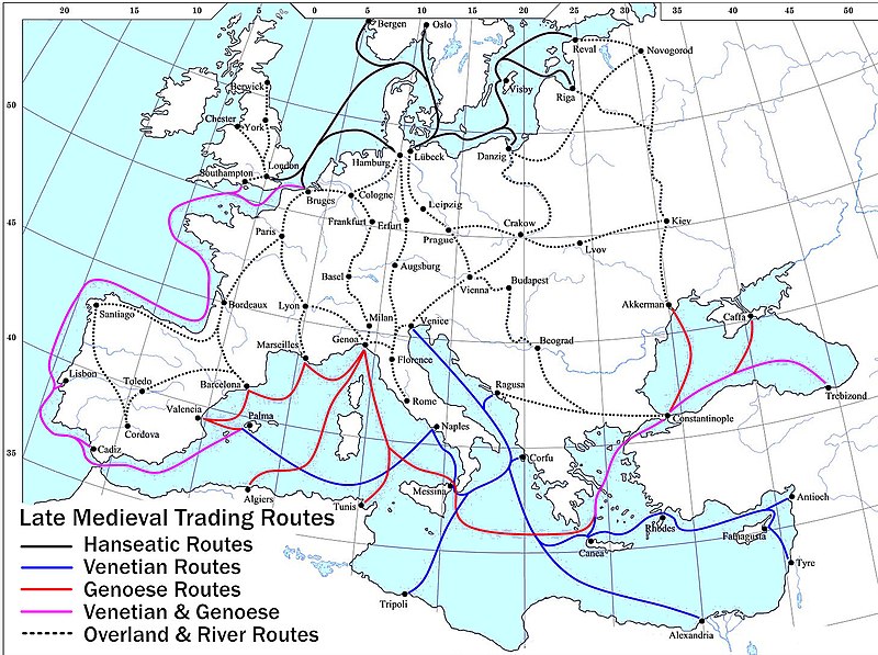
Datoteca:Late Medieval Trade Routes.jpg

Grondezza da questa prevista: 800 × 597 pixels. Other resoluziuns: 320 × 239 pixels | 640 × 478 pixels | 1.024 × 765 pixels | 1.280 × 956 pixels | 1.457 × 1.088 pixels.
Datoteca originala (1.457 × 1.088 pixels, grondezza da datoteca: 372 KB, tip da MIME: image/jpeg)
Istorgia da las versiuns
Clicca sin ina data/temps per vesair la versiun da lura.
| data/temp | Maletg da prevista | dimensiuns | Utilisader | commentari | |
|---|---|---|---|---|---|
| actual | 22:46, 18. matg 2022 |  | 1.457 × 1.088 (372 KB) | Richard2s | Clearer key for map |
| 22:25, 23. schan 2011 |  | 853 × 544 (453 KB) | Micsha~commonswiki | Includes map key on the map | |
| 17:55, 28. mars 2008 |  | 1.817 × 1.120 (487 KB) | Lampman | {{Information |Description=Map showing the main trade routes of late medieval Europe. The black lines show the routes of the Hanseatic League, the blue Venetian and the red Genoese routes. Purple lines are routes used by both the Venetians and the Genoese |
Utilisaziun da la datoteca
La suandanta pagina è colliada cun questa datoteca:
Diever da datoteca global
Die nachfolgenden anderen Wikis verwenden diese Datei:
- Utilisaziun sin ar.wikipedia.org
- Utilisaziun sin be-tarask.wikipedia.org
- Utilisaziun sin bg.wikipedia.org
- Utilisaziun sin ca.wikipedia.org
- Utilisaziun sin da.wikipedia.org
- Utilisaziun sin el.wikipedia.org
- Utilisaziun sin en.wikipedia.org
- Utilisaziun sin es.wikipedia.org
- Utilisaziun sin et.wikipedia.org
- Utilisaziun sin fr.wikipedia.org
- Utilisaziun sin he.wikipedia.org
- Utilisaziun sin hy.wikipedia.org
- Utilisaziun sin it.wikipedia.org
- Utilisaziun sin ja.wikipedia.org
- Utilisaziun sin mk.wikipedia.org
- Utilisaziun sin nl.wikipedia.org
- Utilisaziun sin pl.wikipedia.org
- Utilisaziun sin pt.wikipedia.org
- Utilisaziun sin sh.wikipedia.org
- Utilisaziun sin sl.wikipedia.org
- Utilisaziun sin sq.wikipedia.org
- Utilisaziun sin uk.wikipedia.org
Weitere globale Verwendungen dieser Datei anschauen.


