
Datoteca:Map Italophone World - updated.png

Grondezza da questa prevista: 800 × 370 pixels. Other resoluziuns: 320 × 148 pixels | 640 × 296 pixels | 1.357 × 628 pixels.
Datoteca originala (1.357 × 628 pixels, grondezza da datoteca: 55 KB, tip da MIME: image/png)
| Questa datoteca e las suandantas infurmaziuns provegnan dal deposit multimedia liber Wikimedia Commons. |

|
Dieses Bild des Typs Linguistic map sollte als Vektorgrafik im SVG-Format neu erstellt werden. Vektorformate haben zahlreiche Vorteile; weitere Information unter Commons:Media for cleanup. Wenn dir eine SVG-Version dieses Bildes vorliegt, so lade diese bitte hoch. Nach dem Hochladen der Datei ist diese Vorlage auf der aktuellen Bildbeschreibungsseite durch die Vorlage {{Vector version available}}, oder kürzer {{Vva}}, zu ersetzen. Es ist empfohlen die neue SVG-Datei „Map Italophone World - updated.svg“ zu nennen – dann benötigt die Vorlage vector version available (bzw. vva) keinen Parameter.
|
Resumaziun
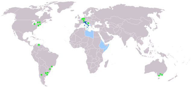
Map made from Image:BlankMap-World.png
| Descripziun |
Deutsch: Legende:
Muttersprache
Amtssprache
Zweit- oder nicht offizielle Sprache
Italienischsprachige Minderheiten English: Legend:
Native language
Administrative language
Secondary language or non-official.
Italophone minorities Español: Leyenda:
Lengua materna
Lengua administrativa
Segunda lengua o lengua no oficial.
Minorías italofonas Français : Carte du monde où on parle l'italien.
Langue maternelle
Langue administrative
Langue importante et/ou langue de culture
Minorités italophones Italiano: Legenda:
Lingua madre
Lingua amministrativa
Seconda lingua o lingua non ufficiale
Minoranze italofone Português: Legenda:
Idioma materno
Idioma administrativo
Idioma secundário, ou não-oficial
Minorias italófonas Polski: Legenda:
Włoski jest językiem ojczystym
Włoski jest językiem urzędowym
Włoski jest drugim lub nieoficjalnym językiem
Mniejszości włoskojęzyczne |
| Funtauna | |
| Autur |
Licenza

|
Es ist erlaubt, die Datei unter den Bedingungen der GNU-Lizenz für freie Dokumentation, Version 1.2 oder einer späteren Version, veröffentlicht von der Free Software Foundation, zu kopieren, zu verbreiten und/oder zu modifizieren; es gibt keine unveränderlichen Abschnitte, keinen vorderen und keinen hinteren Umschlagtext.
Der vollständige Text der Lizenz ist im Kapitel GNU-Lizenz für freie Dokumentation verfügbar. |
| Diese Datei ist unter der Creative-Commons-Lizenz „Namensnennung – Weitergabe unter gleichen Bedingungen 3.0 nicht portiert“ lizenziert. | ||
| ||
| Diese Lizenzmarkierung wurde auf Grund der GFDL-Lizenzaktualisierung hinzugefügt. |
Istorgia da las versiuns
Clicca sin ina data/temps per vesair la versiun da lura.
| data/temp | Maletg da prevista | dimensiuns | Utilisader | commentari | |
|---|---|---|---|---|---|
| actual | 21:40, 27. schan 2022 | | 1.357 × 628 (55 KB) | Jacob300 | Updated Somaliland - Italian was never an official language here |
| 20:25, 29. fan 2021 |  | 1.357 × 628 (29 KB) | MMMM fan | Reverted to version as of 14:07, 3 July 2006 (UTC) Removing outdated or inaccurate Italophone minorities | |
| 11:36, 7. mars 2018 |  | 1.357 × 628 (36 KB) | Maphobbyist | Montenegro and South Sudan borders | |
| 22:22, 5. favr 2014 |  | 1.357 × 628 (39 KB) | Mr. Lama | {{SVG|map}} == {{int:filedesc}} == Map made from Image:BlankMap-World.png {{de|Legende: *Dunkelblau: Muttersprache *Blau: Amtssprache *Hellblau: Zweit- oder nicht offizielle Sprache *Grüne Quadrate: Italienischsprachige Minderheiten}} {{en|Lege... | |
| 16:07, 3. fan 2006 |  | 1.357 × 628 (29 KB) | Fsolda~commonswiki | == Summary == Map made from Image:BlankMap-World.png {{en|Legend: *Dark blue: native language *Blue: administrative language *Light blue: Secondary language or non-official. *green square: italophone minorities}} {{es|Legenda: *azul oscuro: lengua |
Utilisaziun da la datoteca
Naginas paginas mussan sin questa datoteca.
Diever da datoteca global
Die nachfolgenden anderen Wikis verwenden diese Datei:
- Utilisaziun sin ab.wikipedia.org
- Utilisaziun sin en.wikipedia.org
- Utilisaziun sin it.wikipedia.org
- Utilisaziun sin lv.wikipedia.org
- Utilisaziun sin nl.wikipedia.org
- Utilisaziun sin pnb.wikipedia.org