
Datoteca:Schlieffen Plan.jpg

Datoteca originala (963 × 745 pixels, grondezza da datoteca: 732 KB, tip da MIME: image/jpeg)
| Questa datoteca e las suandantas infurmaziuns provegnan dal deposit multimedia liber Wikimedia Commons. |

|
File:Schlieffen Plan fr.svg ist eine vektorisierte Version dieses Bildes. Diese sollte an Stelle des Rasterbildes verwendet werden, sofern sie nicht schlechter ist.
File:Schlieffen Plan.jpg → File:Schlieffen Plan fr.svg
Für weitere Informationen siehe Help:SVG. |
 |
| Descripziun |
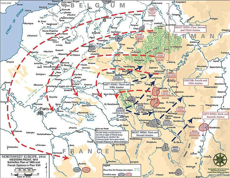
English: Schlieffen Plan
In 1938 the predecessors of what is today The Department of History at the United States Military Academy began developing a series of campaign atlases to aid in teaching cadets a course entitled, "History of the Military Art." Since then, the Department has produced over six atlases and more than one thousand maps, encompassing not only America’s wars but global conflicts as well. In keeping abreast with today's technology, the Department of History is providing these maps on the internet as part of the department's outreach program. The maps were created by the United States Military Academy’s Department of History and are the digital versions from the atlases printed by the United States Defense Printing Agency. We gratefully acknowledge the accomplishments of the department's former cartographer, Mr. Edward J. Krasnoborski, along with the works of our present cartographer, Mr. Frank Martini. Please be aware that these maps are large in file size and may require substantial download times. |
| Data | 05/09/2008 |
| Funtauna | Westpoint.edu, WWI Atlas, Shlieffen Plan |
| Autur | Tinodela |
| Andere Versionen |
|
Dieses Bild wurde von einem Mitglied der United States Army während der Ausführung seiner Dienstpflichten erstellt. Als eine Arbeit der Bundesregierung der Vereinigten Staaten ist dieses Bild in public domain.
|
 |
Derivative works
Abgeleitete Werke dieser Datei: Schlieffen Plan.svg
Istorgia da las versiuns
Clicca sin ina data/temps per vesair la versiun da lura.
| data/temp | Maletg da prevista | dimensiuns | Utilisader | commentari | |
|---|---|---|---|---|---|
| actual | 13:43, 23. fan 2012 | | 963 × 745 (732 KB) | Soerfm | Paris |
| 13:58, 1. mars 2006 |  | 969 × 751 (273 KB) | W.wolny |
Utilisaziun da la datoteca
Las suandantas 2 paginas èn colliadas cun questa datoteca:
Diever da datoteca global
Die nachfolgenden anderen Wikis verwenden diese Datei:
- Utilisaziun sin ar.wikipedia.org
- Utilisaziun sin be-tarask.wikipedia.org
- Utilisaziun sin be.wikipedia.org
- Utilisaziun sin bg.wikipedia.org
- Utilisaziun sin ca.wikipedia.org
- Utilisaziun sin cs.wikipedia.org
- Utilisaziun sin da.wikipedia.org
- Utilisaziun sin de.wikipedia.org
- Utilisaziun sin de.wikibooks.org
- Utilisaziun sin de.wikinews.org
- Utilisaziun sin el.wikipedia.org
- Utilisaziun sin en.wikipedia.org
- Utilisaziun sin en.wikibooks.org
- Utilisaziun sin fi.wikipedia.org
- Utilisaziun sin fr.wikipedia.org
Weitere globale Verwendungen dieser Datei anschauen.