
Datoteca:Vesuve-NASA.jpg

Grondezza da questa prevista: 601 × 600 pixels. Other resoluziuns: 240 × 240 pixels | 481 × 480 pixels | 770 × 768 pixels | 1.026 × 1.024 pixels | 2.052 × 2.048 pixels | 4.089 × 4.081 pixels.
Datoteca originala (4.089 × 4.081 pixels, grondezza da datoteca: 4,63 MB, tip da MIME: image/jpeg)
| Questa datoteca e las suandantas infurmaziuns provegnan dal deposit multimedia liber Wikimedia Commons. |
Resumaziun
| Descripziun |
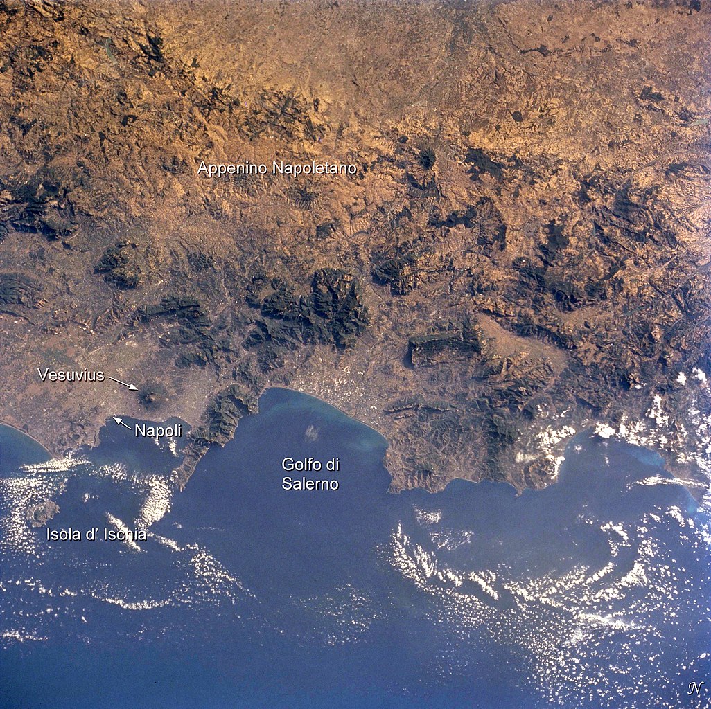
English: Photo of the bay of Naples and the Vesuvius vulcano, taken by Space Shuttle astronauts
Français : Photo satellite de la baie de Naples avec le Vésuve |
| Data | |
| Funtauna | Earth Sciences and Image Analysis, NASA-Johnson Space Center. 16 Apr. 2004. "Earth from Space - Image Information." http://earth.jsc.nasa.gov/sseop/EFS/photoinfo.pl?PHOTO=STS104-710-60 |
| Autur |
NASA |
Diese Mediendatei wurde von einem der Zentren der US-amerikanischen National Aeronautics and Space Administration (NASA) unter der Datei-ID STS104-710-60 kategorisiert. Diese Markierung zeigt nicht den Urheberrechtsstatus des zugehörigen Werks an. Es ist in jedem Falle zusätzlich eine normale Lizenzvorlage erforderlich. Siehe Commons:Lizenzen für weitere Informationen. Sprachen:
|
Licenza
Diese Datei ist gemeinfrei (public domain), da sie vom Image Science & Analysis Laboratory der NASA erstellt worden ist. Die NASA-Urheberrechtsrichtlinie besagt, dass „NASA-Material nicht durch Urheberrecht geschützt ist, wenn es nicht anders angegeben ist“ (NASA-Urheberrechtsrichtlinien-Seite oder Nutzungsbedingungen für Fotos von Astronauten). Die Aufnahme ist Teil der Reihe The Gateway to Astronaut Photography of Earth. Bildquelle: STS104-710-60.
|
Ursprüngliches Datei-Logbuch
(All user names refer to fr.wikipedia)
- 2004-08-05 20:18 Nataraja 540×540×8 (100321 bytes) photo satellite de la baie avec le Vésuve
Istorgia da las versiuns
Clicca sin ina data/temps per vesair la versiun da lura.
| data/temp | Maletg da prevista | dimensiuns | Utilisader | commentari | |
|---|---|---|---|---|---|
| actual | 19:14, 2. dec 2014 | | 4.089 × 4.081 (4,63 MB) | Ras67 | with captions |
| 19:09, 2. dec 2014 |  | 4.089 × 4.081 (4,55 MB) | Ras67 | high resolution without captions | |
| 10:29, 6. favr 2007 |  | 540 × 540 (98 KB) | Bilou~commonswiki | {{Information |Description=photo satellite de la baie de Naples avec le Vésuve |Source=Earth Sciences and Image Analysis, NASA-Johnson Space Center. 16 Apr. 2004. "Earth from Space - Image Information." http://earth.jsc.nasa.gov/sseop/EFS/photoinfo.pl?PH |
Utilisaziun da la datoteca
La suandanta pagina è colliada cun questa datoteca:
Diever da datoteca global
Die nachfolgenden anderen Wikis verwenden diese Datei:
- Utilisaziun sin ca.wikipedia.org
- Utilisaziun sin de.wikipedia.org
- Utilisaziun sin eo.wikipedia.org
- Utilisaziun sin fr.wikipedia.org
- Utilisaziun sin nl.wikipedia.org