Datoteca:Iceland satellite.jpg
Seiteninhalte werden in anderen Sprachen nicht unterstützt.
Ord Wikipedia

Datoteca originala(2.600 × 2.000 pixels, grondezza da datoteca: 869 KB, tip da MIME: image/jpeg)

Vichipedia

 Dies ist eine exzellente Datei in der Wikipedia auf Türkisch (Seçkin resimler) und wird als eine der hervorragendsten Bild-Dateien gewertet.

Wenn du meinst, diese Datei sollte auch auf Wikimedia Commons ein exzellentes Bild werden, dann kannst du sie nominieren.
Wenn du ein Bild vergleichbarer Qualität hast, das du unter einer passenden freien Lizenz freigeben kannst, dann lade die Datei hoch, gib ihr eine korrekte Lizenzangabe und nominiere sie!

Resumaziun

Descripziun
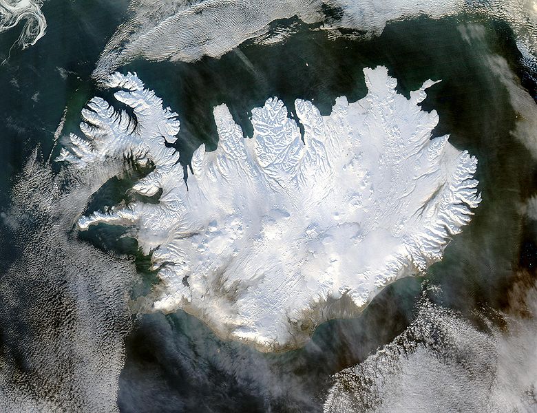
English: Iceland, from the NASA Visible Earth image gallery. More info below
Deutsch: Satellitenbild Islands aus der NASA-Fotogallerie Visible Earth. Mehr Information untenstehend auf Englisch.
Українська: Супутниковий знімок Ісландії, 29 січня 2004 року.
Data 29. schaner 2004
Funtauna http://veimages.gsfc.nasa.gov/6605/Iceland.A2004028.1355.250m.jpg
Autur Jeff Schmaltz
permissiun
(Weiternutzung dieser Datei)
Public domain Diese Datei ist gemeinfrei (public domain), da sie von der NASA erstellt worden ist. Die NASA-Urheberrechtsrichtlinie besagt, dass „NASA-Material nicht durch Urheberrecht geschützt ist, wenn es nicht anders angegeben ist“. (NASA-Urheberrechtsrichtlinie-Seite oder JPL Image Use Policy).
Warnung:

Picture info

  • Description and alternative versions http://visibleearth.nasa.gov/view_rec.php?id=6605
  • Metadata: Sensor Aqua/MODIS
  • Visualization Date: 2004-01-29
  • Credit: Jeff Schmaltz, MODIS Rapid Response Team, NASA/GSFC
  • Description: Iceland lives up to its name in this image, acquired by the Moderate Resolution Imaging Spectroradiometer (MODIS) on NASA's Terra satellite on January 28, 2004. The island country is completely covered in white snow and ice, obscuring the permanent glaciers and icecaps that exist year-round. The effect of ice on this island sandwiched between the North Atlantic and the Greenland Sea, just below the Arctic Circle, is visible along its rugged northern shores. Over millennia, ice has carved out deep fjords leaving fringes of land that extend like fingers into the ocean.
  • Source: ”The purpose of NASA's Earth Observatory is to provide a freely-accessible publication on the Internet where the public can obtain new satellite imagery and scientific information about our home planet. The focus is on Earth's climate and environmental change. In particular, we hope our site is useful to public media and educators. Any and all materials published on the Earth Observatory are freely available for re-publication or re-use, except where copyright is indicated. We ask that NASA's Earth Observatory be given credit for its original materials.”

Kurzbeschreibungen

Ergänze eine einzeilige Erklärung, was diese Datei darstellt.

In dieser Datei abgebildete Objekte

Motiv tudestg

Istorgia da las versiuns

Clicca sin ina data/temps per vesair la versiun da lura.

data/tempMaletg da previstadimensiunsUtilisadercommentari
actual07:49, 5. dec 2004Maletg da prevista per la versiun dals 5. december 2004 las 07:49 uras2.600 × 2.000 (869 KB)Ævar Arnfjörð Bjarmasonbigger version
14:06, 6. nov 2004Maletg da prevista per la versiun dals 6. november 2004 las 14:06 uras540 × 405 (68 KB)RanveigNASA satelite image of Iceland

La suandanta pagina è colliada cun questa datoteca:

Diever da datoteca global

Die nachfolgenden anderen Wikis verwenden diese Datei:

Weitere globale Verwendungen dieser Datei anschauen.

Metadata