
Datoteca:Tibet Karte Topograpisch.png
Grondezza da questa prevista: 800 × 540 pixels. Other resoluziuns: 320 × 216 pixels | 640 × 432 pixels | 1.024 × 691 pixels | 1.500 × 1.012 pixels.
Datoteca originala (1.500 × 1.012 pixels, grondezza da datoteca: 3,08 MB, tip da MIME: image/png)
| Questa datoteca e las suandantas infurmaziuns provegnan dal deposit multimedia liber Wikimedia Commons. |
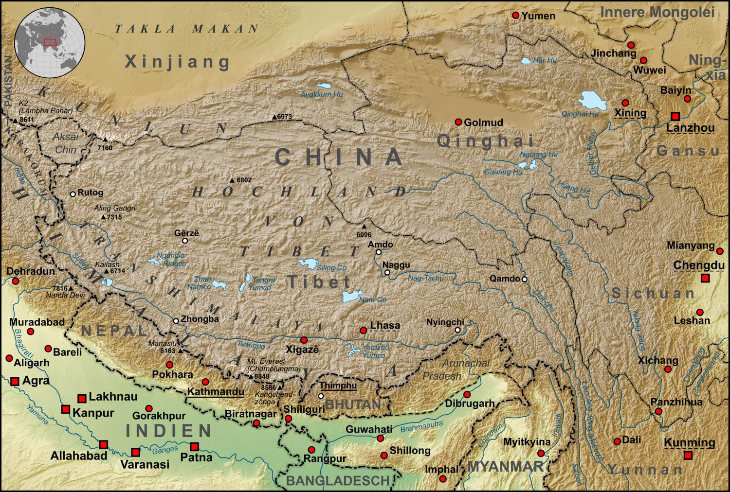
| Descripziun | Topographische Karte der chinesischen autonomen Provinz Tibet, sowie der umliegenden chinesischen Provinzen und der angrenzenden Länder |
| Data | |
| Funtauna |
own work, used:
|
| Autur | Lencer |
| Andere Versionen | Derivative works of this file: ZabuyeLake1.png |
Diese Datei ist unter der Creative-Commons-Lizenz „Namensnennung – Weitergabe unter gleichen Bedingungen 3.0 nicht portiert“ lizenziert.
- Dieses Werk darf von dir
- verbreitet werden – vervielfältigt, verbreitet und öffentlich zugänglich gemacht werden
- neu zusammengestellt werden – abgewandelt und bearbeitet werden
- Zu den folgenden Bedingungen:
- attribuziun – Du musst angemessene Urheber- und Rechteangaben machen, einen Link zur Lizenz beifügen und angeben, ob Änderungen vorgenommen wurden. Diese Angaben dürfen in jeder angemessenen Art und Weise gemacht werden, allerdings nicht so, dass der Eindruck entsteht, der Lizenzgeber unterstütze gerade dich oder deine Nutzung besonders.
- Weitergabe unter gleichen Bedingungen – Wenn du das Material wiedermischst, transformierst oder darauf aufbaust, musst du deine Beiträge unter der gleichen oder einer kompatiblen Lizenz wie das Original verbreiten.

|
Diese Karte wurde in der Kartenwerkstatt erstellt oder verbessert. Auch du kannst dort Karten vorschlagen, die zu erstellen, verändern oder übersetzen sind.
|
Istorgia da las versiuns
Clicca sin ina data/temps per vesair la versiun da lura.
| data/temp | Maletg da prevista | dimensiuns | Utilisader | commentari | |
|---|---|---|---|---|---|
| actual | 08:30, 28. oct 2015 | | 1.500 × 1.012 (3,08 MB) | Lencer | Ulugh Muztagh now 6973 m |
| 08:30, 28. oct 2015 |  | 3.240 × 2.185 (12,63 MB) | Lencer | Ulugh Muztagh now 6973 m | |
| 15:11, 1. mars 2009 |  | 1.500 × 1.012 (3,11 MB) | Lencer | Einige Korrekturen und Ergänzungen | |
| 23:22, 12. dec 2008 |  | 1.500 × 1.012 (3,11 MB) | Lencer | {{Information |Description= |Source= |Date= |Author= |Permission= |other_versions= }} | |
| 10:18, 12. dec 2008 |  | 1.500 × 1.012 (3,11 MB) | Lencer | {{Information |Description= |Source= |Date= |Author= |Permission= |other_versions= }} | |
| 14:57, 11. dec 2008 |  | 1.500 × 1.012 (3,11 MB) | Lencer | {{Information |Description= |Source= |Date= |Author= |Permission= |other_versions= }} | |
| 14:13, 22. nov 2008 |  | 1.500 × 1.012 (3,1 MB) | Lencer | {{Information |Description= |Source= |Date= |Author= |Permission= |other_versions= }} | |
| 16:46, 16. nov 2008 |  | 1.500 × 1.012 (3,09 MB) | Lencer | {{Information| |Description=Topograhische Karte der chinesischen autonomen Provinz Tibet, sowie der umliegenden chinesischen Provinzen und der angrenzenden Länder |Source=own work, used: * Generic Mapping Tools and SRTM30-fi |
Utilisaziun da la datoteca
La suandanta pagina è colliada cun questa datoteca:
Diever da datoteca global
Die nachfolgenden anderen Wikis verwenden diese Datei:
- Utilisaziun sin af.wikipedia.org
- Utilisaziun sin ar.wikipedia.org
- Utilisaziun sin ast.wikipedia.org
- Utilisaziun sin az.wikipedia.org
- Utilisaziun sin bo.wikipedia.org
- Utilisaziun sin ca.wikipedia.org
- Utilisaziun sin ceb.wikipedia.org
- Utilisaziun sin ckb.wikipedia.org
- Utilisaziun sin de.wikipedia.org
- Kunlun
- Transhimalaya
- Autonomes Gebiet Tibet
- Diskussion:Karakorum (Gebirge)
- Hochland von Tibet
- Benutzer:Lencer
- Benutzer:Lencer/Galerie
- Wikipedia:Kartenwerkstatt/Archiv/2008-12
- Diskussion:Transhimalaya
- Wikipedia Diskussion:Hauptseite/Artikel des Tages/Archiv/Vorschläge/2013/Q1
- Wikipedia:Hauptseite/Archiv/14. Februar 2013
- Tibet (1912–1951)
- Pinjarra-Orogen
- Tektonische Entwicklung des indischen Subkontinents
- Geologie des Transhimalayas
- Geologie der Indus-Yarlung suture zone
- Utilisaziun sin el.wikipedia.org
- Utilisaziun sin en.wikipedia.org
- Utilisaziun sin eo.wikipedia.org
- Utilisaziun sin es.wikipedia.org
- Utilisaziun sin eu.wikipedia.org
- Utilisaziun sin fi.wikipedia.org
- Utilisaziun sin frr.wikipedia.org
- Utilisaziun sin fr.wikipedia.org
- Utilisaziun sin ga.wikipedia.org
- Utilisaziun sin gl.wikipedia.org
- Utilisaziun sin he.wikivoyage.org
- Utilisaziun sin hi.wikipedia.org
- Utilisaziun sin hu.wikipedia.org
- Utilisaziun sin hy.wikipedia.org
- Utilisaziun sin it.wikipedia.org
- Utilisaziun sin ja.wikipedia.org
- Utilisaziun sin ku.wikipedia.org
- Utilisaziun sin lld.wikipedia.org
Weitere globale Verwendungen dieser Datei anschauen.